High-resolution stable isotope paleotopography of the John Day region, Oregon, United States
T Kukla, DE Ibarra, JKC Rugenstein, JT Gooley, *CE Mullins, S Kramer, *DY Moragne, CP Chamberlain (2021). Frontiers in Earth Science.
*mentee
The John Day region of Oregon—A case study in the coupling of landscapes and life
The John Day region of east-central Oregon hosts one of the most impressive records of Cenozoic climate and life on the planet. It also spans the base of the Blue Mountains which, today, separate dry desert-lowlands from wetter, wooded highlands. If this gradient existed in the past, identifying it would be critical for interpreting the rich fossil record.
How we reconstructed the history of the Blue Mountains boundary
There are no paleosol carbonates in the John Day region for most of the Paleogene, but clays are abundant, usually forming from altered air-fall ash. We collected clays over space and time in the John Day region for oxygen isotope analysis. Since δ18O generally decreases as mountains force rainout (“orographic precipitation”) oxygen isotopes can be used to reconstruct the Blue Mountains boundary through time.
The Blue Mountains have caused a precipitation gradient for at least 50 million years
We find a consistent ~3‰ offset between the high-δ18O lowlands and low-δ18O Blue Mountains since the Eocene. This is unlikely due to later alteration, as both regions record the same δ18O increase across the Oligocene-Miocene. This local, long-lived δ18O gradient can be explained by the Blue Mountains forcing more rainout and/or relatively more winter (low-δ18O) precipitation.
-
![]()
The modern Blue Mountains—rising above the Cascades rainshadow
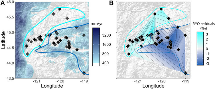
The sedimentary archive of the John Day region (panel B) is considered a window to the uplift of the Cascades (Kohn & Fremd, 2007; Bershaw et al., 2019). But local paleo-elevation was not previously resolved, perhaps confounding signals of Cascades uplift. Since the Blue Mountains mark a region of higher precipitation and biomass today (panels C, D) they may have served as a local climate and ecosystem boundary in the past, too.
-
![]()
Similar trends, but distinct δ18O between across the Blue Mountains boundary
There are two notable features to our oxygen isotope data (plotted with data from the PhD thesis of Takeuchi, 2007). First, the δ18O in the “western facies” (modern lowlands) is ~3‰ higher than in the “eastern facies” (Blue Mountains). Second, both facies show an increase in δ18O between ~25 and 20 Ma. The similar trend makes it very unlikely that recent diagenesis explains the eastern-western facies offset.
-
![]()
The δ18O residuals match the modern Blue Mountains boundary
Lower δ18O in the Blue Mountains might be due to orographic rainout, greater winter precipitation (δ18O is lower in winter) or some combination of the two. We did not find a significant relationship between δ18O residuals and modern elevation or the modern winter precipitation fraction (even when controlling for upstream, catchment conditions). It’s likely that modern conditions are not similar enough to the geologic past to find such a correlation. Whether by more orographic rainout, more winter precipitation, or both, our results point to a robust and long-lived climate gradient surrounding the Blue Mountains.
-
![]()
The history of ecosystems at John Day Fossil Beds National Monument
These spectacular murals by Larry Felder are based on fossils and climate reconstructions from the John Day region through the Cenozoic. But these studies usually did not separate data across the Blue Mountains boundary. Our study poses the question of whether these reconstructions might predominantly reflect the lowlands, highlands, or both? While our findings point to a precipitation gradient since the Eocene, it is not yet clear how this climatic boundary affected Cenozoic life in the John Day region.